Back كلابوزو ARZ Calabozo (kapital sa munisipyo) CEB Calabozo German Calabozo Esperanto Calabozo (Venezuela) Spanish کالابوزو Persian Calabozo (Venezuela) French Calabozo Italian カラボソ Japanese კალაბოსო Georgian
Calabozo | |
|---|---|
City | |
| Villa de Todos los Santos de Calabozo | |
| Nickname: The Agro-industrial Capital | |
| Coordinates: 8°56′N 67°26′W / 8.933°N 67.433°W | |
| Country | |
| State | Guárico |
| Municipality | Francisco de Miranda Municipality |
| Founded | 1 February 1724 by Bartolomé de San Miguel y Fray Salvador de Cádiz |
| Area | |
• Total | 52 km2 (20 sq mi) |
| Elevation | 105 m (344 ft) |
| Population (2022) | |
• Total | 168 605 |
| • Density | 3.239/km2 (8.39/sq mi) |
| Time zone | UTC−4 (VET) |
| Postal Code | 2312 |
| Area code | +58 246 |
| Climate | Aw |

Calabozo, officially Villa de Todos los Santos de Calabozo, is a city in Venezuela located in Guárico state, capital of the Francisco de Miranda Municipality and former capital of the state. It has a population of 168,605, according to the National Institute of Statistics (INE) in 2020. It is located in the center-west of Guárico state, and is one of the main rice producers in the country. In addition, it has the largest irrigation system in Venezuela.[citation needed]
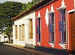
Calabozo, is a mostly colonial city and is linked to its modern urban areas, being the largest colonial center in the country, and is located at 105 m a.s.l. n. m., at the margin of the Guárico River in the high central plain. Its location is on the banks of the Generoso Campilongo Dam, an important work both in its time and today, being the largest in Venezuela and one of the largest in Latin America. It is also the seat of the Roman Catholic archdiocese of Calabozo.


